The Land of Mahafaly
The land of Mahafaly, geographically bounded by the Onilahy River to the north and the Menarandra River to the south, actually begins at the RN 7 level: Most of the charcoal and farming villages south of the table mountain are inhabited by Tanalana migrants (population of the coastal plain of Mahafaly).
 From the eastern crystalline peninsula to the huge limestone plateau that slopes westward into the coastal plain, the Mahafaly agricultural herders, constantly in search of new pastures, practice a transhumance that showcases their legendary cohesion.
Does Mahafaly not literally mean “you who make us happy”?
Until the end of the 19th century, the Mahafaly Kingdoms were respected by their neighbors Antandroy, Antanosy (of Bezaha), Bara, and Masikoro, who did not spare foreign traders, plundered shipwrecks on their coasts, and regularly raided trading posts.
If this region of the Great Subarid South remained mysterious and unexplored for a long time, it is now famous for the talent of its woodcarvers, the originality of its fauna and flora, and its wealth of minerals (fossils, gemstones, and precious stones).
From ANDRANOVORY to BETIOKY
Andranovory
(70 km from Toliara), this city marks the intersection.
Discover our market located near the RN 7 and RN 10. We sell roasted locusts by the kilo, a solution to protect the region’s crops from these insects.
The Tropic of Capricorn
The RN 10 crosses the Tropic of Capricorn about 45 km south of Andranovory. It’s a chance to remember this imaginary line, 23° from the equator, marking the southern boundary of the transition from the sun to the zenith.
Bezaha
The ancient rice farmers of Taolañaro (Fort Dauphin), located in this village 59 km southeast of Andranovory via Inanavy and 22 km east. From Tongobory, inhabitants benefited from an ancient hydro-agricultural development.
Warm (55°C) and sulfuric water, evidence of active volcanism, deafening here and there. The thermal complex built by the South Africans in the 1960s on construction sites has unfortunately completely deteriorated.
Bezaha-Mahafaly Reserve
These 600 hectares of thorny forest on the left bank of the Onilahy River are home to specimens of most plant and animal species in the southern Madagascar (lemurs, radiated tortoises, and Madagascar hedgehogs, or tenrecs…).
A permit from the National Association for the Management of Protected Areas (ANGAP) is required for visiting, and it is recommended to bring a guide as the way there is complicated.
From Betioky to the Mozambique Channel
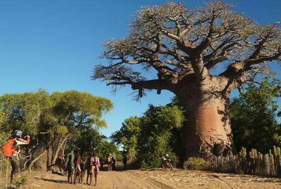
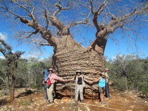
Past the trading town of Tongobory, RN 10 is lined with imposing tombs that are characteristic of the Mahafaly culture. It crosses the dry forest at the foot of small hills to reach Betioky (23 km south). This small town with its streets lined with ornamental baobabs is very lively on market days.
In addition to the exotic products, it is necessary to insist, along with François Sabelli ( Les Marchés ruraux d’Afrique noire, Universalia 1985), on this vocation of a “peripheral market, where economic negotiations are only the apparent aspect of a political relationship, in which the prestige of one is opposed to the calculation of the other”.
Ampanihy is also a Mining Center. Prospectors come to offer tourmalines and garnets to travelers, while the company Delorme, located on the outskirts of the city, sends fine stones to the capital, which, once cut, become solitaire pieces and decorative balls.
After Ampanihy, the relief becomes more hilly and the route more difficult.
In the bush, stretching as far as the eye can see, distances seem to grow larger.
Only the graves rising on both sides of the road, and in the distance a baobab tree with a large trunk, break the unity of the landscape.
Mohair Carpets
Due to the increasing shortage of Angora goats and especially due to serious management mistakes. Founded in the late 1940s, the Mohair House of Ampanihy quickly became a cooperative and closed its doors in the early 1980s.
 However, the weavers, who are either independent or work for a commercial network, still produce magnificent mohair carpets with 20,000 stitches, in brown and/or white, featuring Aloalo, Mahafaly, or Antandroy cross patterns.
The carpets, measuring over 20 square meters, are named after one of the first large buses that served Ampanihy, called Buses.
Passage of the Menarandra River
41 Located 41 km south of Ampanihy, the route crosses the Menarandra River, whose wide bed separates the Mahafaly land from Androy. Herders bring their zebus there to bathe, under the watch of the two monumental tombs adorned with frescoes, wooden panels, and Bucranes, located on the hill above the left bank.
Tranoroa (41 km east of Ampanihy), this large village lost in the bush with only one grocery store is the center of graphite mining operated by South African companies.
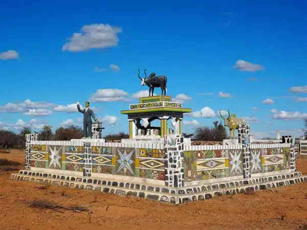
Mahafaly Tombs
Like the Antandroids, the Mahafaly built huge individual tombs following the model of royal tombs, often exceeding 200 m² in size.
Bucranes and Aloalo (carved and painted wooden posts) adorn their tops, and naively painted geometric motifs or scenes from the daily lives of the deceased sometimes run along the masonry walls.
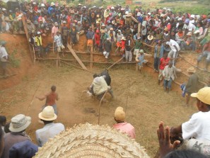
The construction of these memorial tombs and the ceremonies preceding the burial can last several months and be associated with very costly zebu sacrifices. The Mahafaly are quite tolerant of the presence of strangers at these ceremonies.