The Ethnic Groups in Madagascar – The Merina Tribe

Discover the Merina tribe in Madagascar and their geographical distribution. Learn about the Ankaratra Massif, a central part of the islands North-South ridge, visible from Antananarivo year-round. Explore the main ridge, reaching over 200 meters in height for nearly 100 kilometers, culminating in Tsiafajavona at 2,643 meters. Dive into the rich culture and history of this unique tribe.

Madagascar Tribes-MERINA

The geographical distribution of the Merina

The Ankaratra Massif, visible from Antananarivo at all times of the year, forms the central part of the island’s north-south ridge. The main ridge line runs more than 200 meters above almost 100 km and culminates in Tsiafajavona (“where the mist never clears”) at 2,643 meters.

At the foot of this mountain, in Ambohitrakolahy (“the hill of the rooster”), according to legend, the daughter of the heavenly ruler Andriananahary married a rooster and a hen.

Legend has it that the rice cultivation was born when a woman came to Earth. She sacrificed the rooster and took Paddy seeds from her harvest, sowing them, thus giving birth to rice cultivation.

From the heights of Ankaratra, the view leads to the capital in the north, to the Itasy Lake in the west, to the forest of Tsinjoarivo in the east, to the rice paddies of Sambaina and Vinaninony in the south, all the way to the peaks of the Malagasy Highlands.

Exploring the Massif

Ankaratra offers a variety of landscapes – tree ferns in the humid forests, pine forests, moors, rare flowers like orchids, barren mountains, huge rocks – and a wide range of hiking opportunities.

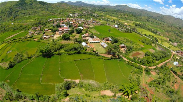
Discover Ambatolampy, a picturesque village located 68 km south of Antananarivo on the RN7. This village is crossed by a large path, once used by herds of Zebu, now frequented by 4x4s and mountain bikes, crossing the massif from east to west.

The route passes through Faratsiho, the highest city in Madagascar (1,792 m), over the Mahafompona Pass (2,386 m). From there, you can reach Antsirabe via the RN 43 and Sambaina, or through Vinaninony and Ambano (45 km of track through orchards).

MANJAKATOMPO Forest and Fish Farm Station

Just before Ankeniheny (7 km west of Ambatolampy), a road leads to the MANJAKATOMPO Forest and Fish Farm Station. Visit the Manjakatompo Forest and Fish Farming Station, accessible with permission from ANGAP (National Association for the Management of Protected Areas).

This preserved area of 1,000 ha, where efforts are being made to restore the Primary Forest of Ankaratra, offers pleasant hiking and camping opportunities, especially between March and June when everything is still green.

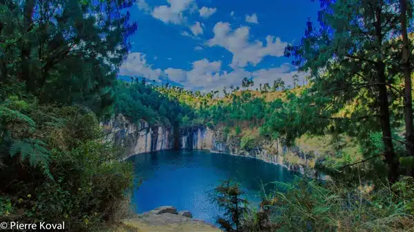
Although fishing and hunting are strictly prohibited, its waterfalls and rivers provide a pleasant coolness and you can swim in Lac aux Dames or Lac Froid. A Small hiking trail, south of the fish station, leads to the Mimosas Arboretum.

From the parking lot next to the orientation table (at an altitude of 2,111 m) and the Anosiarivo Arboretum, sports enthusiasts can reach the summit of Tsiafajavona (2,643 m) and its cairn in a few hours, at the foot of which the locals deposit offerings.

TSINJOARIVO (45 km southeast of Ambatolampy)

In this magnificent place, once densely wooded, overlooking the course of the Onive, Ranavalona had a holiday palace built in 1840.

East of the Rova (royal citadel), the Onive (150 m) flows in tumultuous waterfalls, the Andriamamovoka waterfalls, down the hill (150 m). Tsinjoarivo, the “thousand viewpoints”, is a sacred place where.

During the Malagasy New Year festival, processions are organized.

ANTSIRABE, “where there is plenty of salt” (167 km south of Antananarivo via the RN7)

Antsirabe, the Coquette, is located at an altitude of 1,550 m in a basin surrounded by the volcanic cones of 
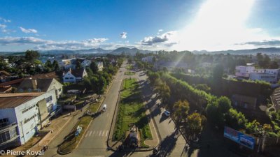
Famoizankova in the north (2,367 m), Vontovorona in the east (2,055 m), Ibity in the south (2,240 m), and Itongafeno in the west (2,202 m). This quiet high-altitude town has a healthy climate, but also the coolest in Madagascar: in winter, the temperature can drop to 0°C.

History of Antsirabe

Antsirabe was once just a small village where locals came to stock up on salt, until Norwegian missionaries, enticed by its cool climate and healing virtues of its thermal spring, opened the first spa in the 1870s.

Soon equipped by the French with a bathhouse, a luxurious hotel, a train station, and a post office, the “Madagascan Vichy” experienced the splendor of colonial resorts in the first half of the 20th century.

The “City of Wonders”.

This small museum in Antsirabe was founded by the dean of mining operators in Madagascar. It presents a beautiful collection of minerals from various. Regions of the island as well as specimens of rubies, emeralds, and sapphires.

Antsirabe, with almost 80,000 inhabitants, has become a renowned center for cutting and trading valuable minerals. It also thrives through its fruit and dairy production and its industries (including Star breweries, manufacturers of Three-Horse Beer, a cigarette factory, and textile industries, including Cotona, the first cotton spinning mill on the Big Island).

Hiking in Antsirabe

It is a green city with wide avenues where you can explore by rickshaw, bicycle, or.

Explore the city center of Merina, where you can take a horse ride and admire its colonial villas with old-fashioned charm.

The city center is organized around the Grande Avenue, an artery that connects the train station to the impressive Hôtel des Thermes. This recently restored palace is worth a visit for its colonial architecture and pleasant gardens. Behind the hotel, on the banks of Lake Ranomafana, the thermal facility welcomes patients in its Belle-Époque decor for the treatment of liver diseases and rheumatism.

Experience the benefits of bicarbonate… Experience the relaxing benefits of Ranovisy’s sodium water by taking a soothing bath in the hot thermal pool. To the southeast of the lake, on Avenue de l’Indépendance, a market takes place daily, while to the west of the lake, on rue Le Myre-de-Vilers, the Grand Marché d’Asabotsy is in full swing on Saturdays.

Exploring the Surroundings of Antsirabe

Follow the road to Belazao for 3 km to reach the Ivohitra Peak, a viewpoint that dominates the entire region. The Antsirabe basin, extending west to Betafo, is an important agricultural center.

Here, wheat, rice, and corn are grown, making it the largest agricultural area in the region. Producer of fruits and vegetables in a temperate climate and the largest producer of dairy products on the Big Island. Wine production is also important (4,000 hl/year).

ANDRAIKIBA Lake (7 km west of Antsirabe, via a dirt road at KP6 of RN 34)

This huge body of water, once a popular Sunday stroll and bathing spot during colonial times, has returned to a desolate solitude, but there are plans to reopen the yacht club.

BETAFO (22 km west of Antsirabe, on RN34)

This town with a large market is an important rice center. Located around a crater lake, the Tatamarina, it does not lack charm with its beautiful pink brick houses. With wrought iron balconies typical of highland architecture.

In the marketplace, six granite stones honor the memory of brave warlords, while the ancient Rowa on the other side of the lake reminds us that Betafo was the capital of Vakinakaratra. From the lake, you will meet the fishermen, a path leads through the fields to the Antafofo waterfalls (5 km round trip).

TRITRIVA Lake (17 km southwest of Antsirabe)

This very deep lake, located in a caldera, exudes an aura of unsettling strangeness. Its level

The water level of the crater lake at Mount Ibity mysteriously decreases during the rainy season and rises again during the dry season.

According to legend, Rabeniomby and Ravolahanta, two lovers from the 19th century who were not allowed to be together by their parents, plunged into its dark waters.

They transformed into the two trees with intertwined branches that can be seen hanging on the side of the crater.

Mount Ibity (30 km south of Antsirabe, via Vinaninkarena, on the RN 7).

This mountain, which can be climbed during the day (2,255 m), contains fossil stones and crystals, while the Sahatany Valley on its western flank provides the fine stones that can be bought in the city:

Tourmaline, Beryll, Garnet, Amethyst, Topaz…

Travel Souvenirs, 1865-1870

“The Merinas love to have the ceilings of their main houses covered in black soot, as they say; the webs that the spiders weave there are laden with soot produced by the hearth, which is constantly maintained and whose smoke can only escape through the roof gap or the door… and the older the house, the more soot there is, the prouder they are of their home, as it is evidence that it has been in the family for a long time, that it has been inhabited by a long line of generations.”

“And therefore all the more respectable, esteemed, and revered.” – Alfred Grandidier

Explore more about Madagascar